


.png)
Number of search results:
35
Nakama River Bog Rock Formation of Wamigawa River
サイト名:
サイト分類:
Geosite
サイト番号:
3

The Nakama River Megabloc Formation, a simultaneous anomaly in the upper part of the Tsurukawa Conglomerate Formation of the Iwadonoyama Formation, can be observed. This formation is characterized by a large amount of subangular pyroxene andesite breccia, with maximum breccia diameters reaching nearly 2 meters. Other breccia types include sandstone, shale, and chert, primarily consisting of poorly sorted angular breccia. Due to the tuffaceous matrix and high degree of consolidation, numerous small waterfalls can be seen on the riverbed.
From this, it is thought that the Nakama River Megabloc Formation was formed by the deposition and formation of volcanic mudflows generated by nearby volcanic activity in a localized depression.
Tsurukawa Conglomerate Formation below Uenohara High School
サイト名:
サイト分類:
Geosite
サイト番号:
4

The Tsurukawa Conglomerate Formation (deposited approximately 6 to 4 million years ago) is exposed on the riverbed of the Tsurukawa River in this area. The gravel consists mainly of sandstone, mudstone, and chert, with a small amount of volcanic rock. The gravel diameter ranges from 3 to 20 cm, and it is composed of subangular to subrounded pebbles. Overall, sorting is poor, and the poorly sorted areas have a particularly high proportion of angular pebbles, suggesting that debris flow deposits were transformed into conglomerate.
Furthermore, the Tsurukawa Conglomerate Formation in this area is interspersed with softer sandstone layers, and the continuity along the strike direction tends to be poor. Occasionally, blackened, carbonized plant fragments are also found. Therefore, it is thought that the Tsurukawa Conglomerate Formation in this area was deposited in an unstable environment, such as a braided riverbed, where debris flows occasionally surged.
Iwadonoyama Conglomerate Formation, Tsurushima Land Improvement District
サイト名:
サイト分類:
Geosite
サイト番号:
6

You can observe the Iwadonoyama conglomerate layer. The outcrop consists of well-stratified alternating layers of conglomerate and sandstone, exhibiting a strike and dip of N85°E and 76°N. Graded structures are visible in parts of the conglomerate. The pebbles in the conglomerate are sandstone, mudstone, and chert originating from the Kanto Mountains (Shimanto Belt). The pebbles are approximately 3 cm in diameter, well-sorted, and rounded. A high-angle fault of N15°E and 78°W is visible near the center of the outcrop.

Iwadono-yama and Tsurukawa Conglomerate Formation in Higashi-Ono
サイト名:
サイト分類:
Geosite
サイト番号:
20

At this outcrop, you can observe the boundary where the Iwadonoyama Conglomerate and the Tsurukawa Conglomerate of the Iwadonoyama Formation meet. The Iwadonoyama Conglomerate is gray, highly consolidated, and composed solely of rounded pebbles originating from the Kanto Mountains, while the Tsurukawa Conglomerate is brown, less consolidated, and contains not only clastic rocks but also volcanic rocks and volcanic clastic rock pebbles originating from the Tanzawa Mountains. The bedding planes are tilted at a high angle to the north, and the base of the Tsurukawa Conglomerate appears to be a transition zone between the two conglomerate layers. A nearly vertical fault can also be observed in the Tsurukawa Conglomerate. This is a very valuable location where you can observe two types of conglomerate layers in a single outcrop.
Sandstone and mudstone interbeds at the top of the shelves
サイト名:
サイト分類:
Geosite
サイト番号:
21

This is an outcrop of rocks from the Sagamiko Group, which constitutes the Shimanto Belt accretionary complex. The rocks are dark gray to bluish-gray mudstone and sandstone, with some of the mudstone having been transformed into hornfels by heat. The interbedded sandstone and mudstone in this area exhibit clearly defined bedding planes.
Because the rocks are hard and firmly consolidated, the surrounding mountains have a steep topography. The Nakama River flows in a straight line, forming a deep V-shaped valley.
Biryu-kan
サイト名:
サイト分類:
Geo-Eco-Cultural
サイト番号:
2

This is a community hub facility located in the mountainous area of the Nishihara district in Uenohara City. It features a cafeteria, local products, and experiential activities (such as soba noodle making), and also serves as a base for local events (Nishihara Festival) and geotours.
Mew's Forest
サイト名:
サイト分類:
Geo-Eco-Cultural
サイト番号:
3

Located in a mountain valley in Yuzuhara, this outdoor complex is themed around a fantasy world. In addition to accommodation (glamping), it offers seasonal events, workshops using natural materials, mystery-solving activities, and village-building experiences. It incorporates explanations of the area's formation and the surrounding folded sandstone layers (marine deposits), utilizing it for both tourism and educational purposes.
Uenohara Station North Exit / Spring Water and Stone Wall
サイト名:
サイト分類:
Geo-Eco-Cultural
サイト番号:
18

Uenohara Station is situated in a highly constrained location, "mid-slope to directly below the terrace cliff" on the north bank of the Katsura River. The north exit is closer to the terrace surface (the elevated urban area), while the south exit is closer to the lowlands (the valley floor). The difference in elevation between the two sides can be experienced firsthand by walking around, demonstrating how topography determines transportation and the shape of the town, with the station itself serving as a teaching tool.
Shobu Renbashi
サイト名:
サイト分類:
Geo-Eco
サイト番号:
1

This suspension bridge spans the Tsurukawa River in the Yuzuhara and Ozuku districts of Uenohara City. The area around the bridge boasts a beautiful gorge landscape, and approximately 300 meters downstream from the bridge is said to be "Unagi-buchi," a waterfall with a drop of about 30 meters. It has been reported that local residents developed a walking path leading down from the bridge to the waterfall, making this an example of a community proactively transforming a scenic resource into a "visitor resource."
Tomioka Rice Terraces
サイト名:
サイト分類:
Geo-Cultural View
サイト番号:
7

This is a terraced rice paddy landscape located above the Tomioka settlement in the Akiyama district of Uenohara City. The arrangement of the settlement and cultivated land reveals the human activity that enabled the cultivation of rice paddies under the mountainous terrain. Viewing is primarily from roads and farm paths.
Kingi Rock (Longmen Gorge)
サイト名:
サイト分類:
Geo-Cultural View
サイト番号:
15

This distinctive rock formation is located in the Katsuragawa Gorge in Uenohara City, Yamanashi Prefecture, and is known by its name among local residents. Both banks are sheer cliffs, and geologically, it belongs to a Neogene marine conglomerate layer.
It is known that the literary figure Yosano Tekkan named the gorge "Ryumonkyo" (Dragon Gate Gorge) after this rock.
Guntori Shrine
サイト名:
サイト分類:
Geo-Cultural
サイト番号:
1

Guntori Shrine is a religious center nestled in the mountains near the border of Musashi, Sagami, and Kai provinces. It is said to have been relocated from the summit of Mount Mikuni (Mount Shōtō) to the Ido district during the Bunroku era. In the back of the shrine grounds stands the "Katsura Tree of Guntori Shrine," a prefecturally designated natural monument. It is also known as the "Water Tree" because clear water is said to spring from its base.
Yatsusawa Hydroelectric Power Plant
サイト名:
サイト分類:
Geo-Cultural
サイト番号:
4

This is a canal-type hydroelectric power plant constructed during the Meiji period to meet the long-distance power transmission needs of the Tokyo metropolitan area. The approximately 14km stretch from the water intake to the power plant consists of a series of civil engineering structures including aqueducts, tunnels, and regulating reservoirs, and is still used for power generation today. It holds significant historical value in the history of civil engineering and is designated as a National Important Cultural Property (structure).
Tenjin Tunnel
サイト名:
サイト分類:
Geo-Cultural
サイト番号:
5
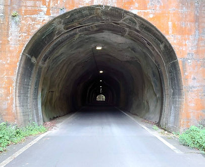
This is a hand-dug tunnel from the Meiji period, piercing the surrounding steep igneous mountain range. It was excavated between 1901 and 1910 by the village headman at the time, using his personal funds, with the aim of reducing the frequent accidents involving people and horses falling over the mountain pass. The northern entrance is composed of andesite to basaltic andesite, while the southern entrance is composed of dacite to rhyolite, showing significant differences in lithology and age over short distances.
Kanayama gold mine ruins
サイト名:
サイト分類:
Geo-Cultural
サイト番号:
6

This is a gold mining site remaining in the Akiyama district (Kanayama). There is a legend of the Takeda clan's "hidden gold mine," and the surrounding area features a museum displaying mining remains and refining tools, as well as a gold panning experience in the stream. It serves as a base for learning about local history and mining technology.
Komoa Shiotsu
サイト名:
サイト分類:
Geo-Cultural
サイト番号:
7

This urban facility connects the area in front of JR Chuo Main Line's "Shiotsu" Station (valley bottom side) with "Comoa Shiotsu," a large-scale residential area built on a hillside in front of the station (hillside side), via the "Comoa Bridge" (inclined elevator/escalator), which overcomes an elevation difference of approximately 88 meters. This "vertical movement" serves as an educational tool that allows general visitors to experience firsthand how the topographical conditions of the Katsura River basin (valley bottom and hills/slopes) directly influence residential development, transportation routes, and barrier-free design.
Former Sakurai Elementary School
サイト名:
サイト分類:
Geo-Cultural
サイト番号:
9

The former Sakurai Elementary School (gymnasium, etc.) is a public facility located in the Akiyama district. It is available for rent upon application and serves as a venue for local gatherings, sports, and other activities. • From fiscal year 2028, it will be utilized as a geopark education and exchange hub (related facility).
• The eastern slope of the grounds will be restored by removing the concrete covering, allowing for observation of folded strata.
Across the river from Tsurukawa-juku
サイト名:
サイト分類:
Geo-Cultural
サイト番号:
10

The gravel outcrop on the opposite bank of Tsurukawa-juku is the only outcrop where almost the entire gravel layer of the Uenohara river terrace (approximately 60m) can be observed from bottom to top. The lower part of the outcrop (approximately 30m) consists of deposits from debris flows, while the upper part is predominantly composed of riverine gravel.
Shimada Land Improvement District
サイト名:
サイト分類:
Geo View
サイト番号:
2

The Shimada Land Improvement District is an organization responsible for the maintenance and management of agricultural water facilities, etc., based on the Land Improvement Act. As the main operator of water resources supporting agricultural land use in the Katsura River basin, it is responsible for the maintenance and management of water intake, distribution, and irrigation/drainage facilities.
The area was reclaimed from a valley of a Katsura River tributary using excavated soil from the linear motor car tunnel, creating new agricultural land. This unexpectedly created river terrace offers a spectacular view of its entirety. On both banks of the stream below the plateau, there are outcrops of conglomerate rock layers rising at approximately 60 degrees, exhibiting a graded structure.
Akiyama Onsen
サイト名:
サイト分類:
Geo
サイト番号:
3

This day-trip hot spring facility is located in a satoyama (traditional Japanese rural landscape) valley surrounded by the Akiyama River and Anjisawa River. The surrounding area is known to contain Neogene basalt, and the valley topography and igneous rock landscape serve as a base for learning about "water cycles (groundwater) and daily life."
Tsurushima Terrace Slope
サイト名:
サイト分類:
Geo
サイト番号:
11

A terrace cliff (terrace ledge) of a river terrace developed in the Tsurushima district on the right bank of the Katsura River. A typical erosion terrace cliff. This location can simultaneously explain when and how the river terrace was formed, based on both the geological strata and the topography.
Tsurukawa Fault Segment
サイト名:
サイト分類:
Geo
サイト番号:
12

This site in the Tsurukawa River basin (Yuzuhara area) is said to allow observation of the structure of a fault (Fujinoki-Aikawa fault line) that cuts through the geological layers. The evaluation sheet designates it as having "high geosite value" and being a "typical fault outcrop," making it an entry point for learning about underground mechanical processes such as deformation and fracture of geological layers in a field setting.
Uba no bosom
サイト名:
サイト分類:
Geo
サイト番号:
14

This geosite is located along a stream in Uenohara City, and marine conglomerate and mudstone layers are exposed on the riverbed. Fossil findings have been reported in the vicinity, making it a starting point for considering sedimentary rocks and paleontology (unreviewed information).
Yaeyama
サイト名:
サイト分類:
Ecosite
サイト番号:
1

Yaeyama Mountain was named in honor of Yae Mizukoshi, who was born and raised in Uenohara in the early Showa era. She donated the mountain to the town of Uenohara and Uenohara Elementary School as a token of gratitude for the support she received.
With easy access from the city center, it's a mountain that appeals to the five senses, loved by many both inside and outside the city. Multiple routes are available, each themed around the five senses: seeing, hearing, smelling, touching, and tasting, allowing you to enjoy hiking not just once, but many times.
Near the summit, there's a wooden observation deck where you can enjoy panoramic views of the magnificent scenery from Uenohara. We recommend having a picnic lunch at the observation deck while gazing at Mount Fuji. The changing flowers of each season, the chirping of birds, the footprints of small animals... countless discoveries await you.
Ohno Reservoir
サイト名:
サイト分類:
Eco-cultural
サイト番号:
4

The Ohno Reservoir is a scenic waterside location in Uenohara City, renowned for its cherry blossoms. Furthermore, it holds significant value in the history of modern civil engineering and energy, as a "regulating reservoir" deeply connected to Japan's earliest full-scale hydroelectric power generation facilities (the Yatsusawa Power Plant), which utilized water from the Katsura River system. The Yatsusawa Power Plant facilities are a nationally designated Important Cultural Property, characterized by their large scale, with the intake, regulating reservoir, tunnels, and aqueducts extending approximately 14 km.
Inume Inn
サイト名:
サイト分類:
Cultural site
サイト番号:
8

Inume-juku is believed to have been newly established in 1713 (Shōtoku 3) as a post town on the old Kōshū Kaidō road, in an area that was previously uninhabited. There is a legend that the original settlement was located at "Tsuchibashi," about 700m to the south, making it a point where road policies (defense and transportation) and settlement formation were intertwined. The post town is situated on a mountainous plateau, and Mount Fuji can be seen from around Inume Pass. It is also known as a scenic spot depicted in ukiyo-e prints by Katsushika Hokusai and Utagawa Hiroshige. In 1970 (Shōwa 45), most of the post town was destroyed by fire, but a streetscape of about 200m remains neatly intact, conveying the atmosphere of the post town to the present day.
Nodajiri Inn
サイト名:
サイト分類:
Cultural site
サイト番号:
9

This was a post town on the old Koshu Kaido road, which flourished as a medium-sized post town from the Edo period to the Meiji period. Its street layout, with its entrances shaped like a key and limited visibility, is said to have extended approximately 400 meters. A monument remains commemorating a brief resting place taken by Emperor Meiji.
Inume-juku (Ono Observatory)
サイト名:
サイト分類:
Cultural View
サイト番号:
1

Inume-juku is believed to have been newly established in 1713 (Shōtoku 3) as a post town on the old Kōshū Kaidō road, in an area that was previously uninhabited. Legend says the original settlement was located about 700 meters south at "Tsuchibashi," highlighting the connection between road policy (defense and transportation) and settlement formation. The post town is situated on a mountainous plateau, offering panoramic views of Mount Fuji from the Inume Pass area, and is known as a scenic spot depicted in ukiyo-e prints by Katsushika Hokusai and Utagawa Hiroshige. While most of the post town was destroyed in a major fire in 1970 (Shōwa 45), approximately 200 meters of the townscape remains neatly preserved, conveying the atmosphere of the post town to the present day.
Hometown Longevity Hall
サイト名:
サイト分類:
Cultural
サイト番号:
2

This is a community hub facility in the Yuzurihara district. Visitors can experience local ingredients and regional food culture through the shop and restaurant. Within the Yamanashi Uenohara Geopark concept, it is positioned as an explanatory point connecting Yuzurihara's mountainous valley topography with the local way of life (old farmhouses, cultivated fields, wild boar fences, etc.) based on Paleogene marine sandstone layers.
Kurodazawa Siphon
サイト名:
サイト分類:
Cultural
サイト番号:
2

The Uenohara Irrigation Canal is an agricultural water supply system that draws water from the Tsurukawa River and directs it to the cultivated fields on the Uenohara surface (a river terrace). Its total length is approximately 8.7-9 km, and construction began and was completed during the Taisho period. Because the water is guided by gravity from the intake, the irrigation channel has a gentle slope, and water management facilities such as the "Kurodazawa Siphon (U-shaped inverted siphon)" are installed along the way to cross valleys. The establishment of this irrigation system embodies the pursuit of water resources (the slow, steady weariness) necessary to sustain life on the terraced terrain.
Katsuragawa Fisheries Cooperative
サイト名:
サイト分類:
Cultural
サイト番号:
3

The Katsuragawa Fisheries Cooperative is responsible for enforcing regulations regarding recreational fishing on the Katsuragawa River (upper reaches of the Sagami River system), providing information on fishing licenses, and managing resources such as fish stocking. It serves as a "gateway" connecting the local food culture (including ayu fish) and the relationship between the river and its people to the present day.
Uenohara Waterway and Tsukimi Pond
サイト名:
サイト分類:
Cultural
サイト番号:
19

This reservoir was constructed to ensure a stable water supply to farmland from the Uenohara irrigation system. It is the only reservoir in Yamanashi Prefecture to be selected as one of the 100 best reservoirs by the Ministry of Agriculture, Forestry and Fisheries.
A casual stroll through Uenohara
サイト名:
サイト分類:
Base facilities
サイト番号:
4

This facility, located adjacent to the south exit of JR Uenohara Station, serves as a tourist information and local product sales hub. As a first stop for visitors, it provides a quick overview of the geopark's highlights (topography, geology, and culture) and offers a well-defined route for exploring the area. The second floor houses "Wine Wall Uenohara," a shop showcasing locally produced wines, further enhancing its ability to promote tourism and regional products.
Uenohara Archive Room
サイト名:
サイト分類:
Base facilities
サイト番号:
5

The History and Culture Exhibition Room, located within the Uenohara City Cultural Hall (Momiji Hall), displays history, cultural artifacts, and traditional performing arts from the Jomon period to the present day. It also hosts special exhibitions and guided tours by curators. This serves as a hub that complements the geopark's "culture and history (people)" within an indoor setting.